Breadcrumb
Blogs
Cyclical movements in the Latin American economy show close links to fluctuations in mineral pricing
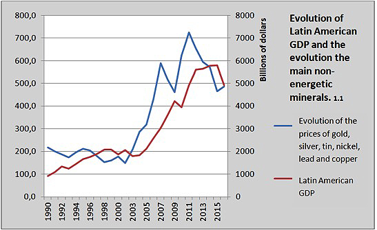
The attention of public opinion on the price of commodities usually focuses on hydrocarbons, especially oil, because of the direct consequences on consumers. But although there are important oil producers in Latin America, minerals are a more transversal asset in the region's economy, especially in South America. This is shown by the largely parallel lines that follow the evolution of non-energy minerals and GDP growth, both in times of boom and of decline.
ARTICLE / Ignacio Urbasos Arbeloa [English version] [Spanish version].
Mining activity is a fundamental sector for most of the Latin American economies. The sector has a huge weight on exports and the attraction of foreign direct investment making it one of the most important sources of international currencies. Against the general perception of the non-energetic mining activities as a mature industry, the sector has demonstrated its capability to be attractive for investment and able to produce jobs and wealth. Latin American mining is the destiny of 30% of world investment in the sector, which is waiting for a rising in prices. The effect of these price fluctuations have direct consequences on the economies of the continent, some of them being deeply dependent on the exploitation and sell of its natural resources. The main goal of this analysis is to articulate a convincing explanation of the impact of price fluctuation on non-energetic minerals on national GDPs.
Firstly, it is important to explain the chronological evolution of prices in the most exploited minerals of Latin America. The general tendency of commodity prices during the last two decades has been marked by a great volatility. The so called super cycle of commodities [1] produced between 2003 and 2013, with recoil during 2008 and 2009, coincides with the golden decade of Latin America. This situation was produced thanks to an unprecedented rising of global demand, mainly of the emerging countries led by China. In fact, the rising of China has transformed the trade pattern in the region which is today the main trade partner of a large number of countries.
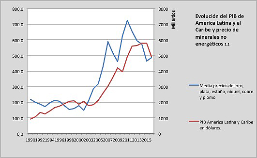
The mentioned evolution in commodity prices is similar to the one of the non-energetic minerals, which generally follows the tendencies of raw materials. As graph 1.1 shows, the region of Latin America and Caribbean has growth in correlation to the average evolution of the prices of gold, silver, tin, nickel, lead and copper. It is important to mention that this correlation in not an isolated one, and has to be analyzed in the context of a general rising in natural resource-based products such as hydrocarbons and agricultural goods.
|
[The graphics have been made from World Bank Data and national statistics of Peru and Chile]. |
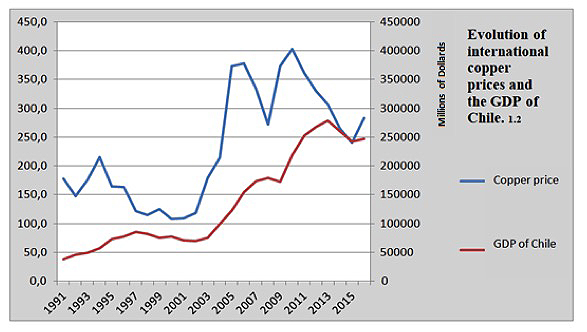
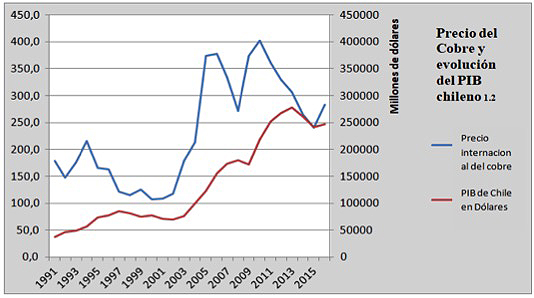
The Chilean case can be illustrative. The country has an economy particularly specialized on non-energetic minerals, outstanding copper as a core mineral for the country. Chile is the main producer of copper in the world and this mineral is around 50% of the national exports. The mining sector in Chile [2] represented 20% of the country's GDP during the 2000's, in 2017 it is only 9% of its economy. In graph 1.2 it is evident how the economic growth of Chile is directly linked with the different prices of copper. Even though it is one of the most complex and developed economies in the continent, with a tertiary sector [3] representing 74% of its GDP, Chilean economy is still dependent and affected by copper prices and the situation of the mining industry.
|
|
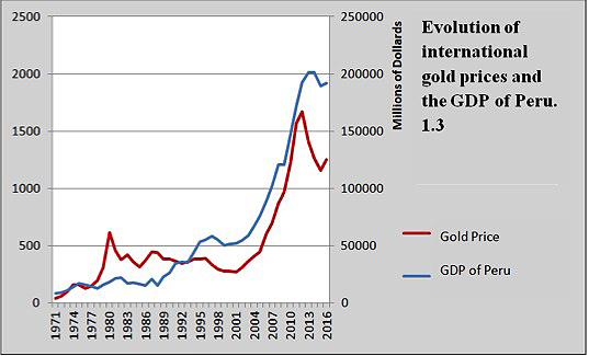
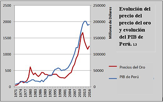
Another interesting case is the Peruvian one, a country whose exports are in a big proportion composed by non-energetic minerals. Gold is 18% and copper is 26% of all exports [4], reaching both more than 46% of them. Similar to the case of Chile, 15% of its national GDP comes from the mining activities. Again, the correlation of mineral prices and economic growth is evident in graph 1.3, showing the huge dependence of these economies to the international prices of their exports.
|
|
This relationship is logical and has its answer in different realities. On the one hand, the quantitative value of natural resources on the Latin American economies, whose exports are mainly composed by mineral, agricultural or energetic commodities. On the other hand, the qualitative importance of the mining sector, which creates huge amounts of employs (up to 9% of the total in Chile), is the activity of some of the main companies in the region (among the 20 biggest companies in the Latin America, 5 are related to the mining activities), it is the main source of currencies and support public budgets by its particular fiscal regime. Equally, a big amount of national public debts are covered by those particular taxes, creating a situation of possible default in case of great fluctuations of prices. This menace brings back the memories of the debt crisis in the 80's, something that it is now a reality in the case of Venezuela.
Must be taken into account that Latin American countries are not a unicity or a homogeneous reality, in general it is true that the region confronts a general challenge: be able of reduce the dependence of their economies to the exploitation and sell of its natural resources. An economic structure that is problematic because of its impact on the environment, a particularly complex issue because of the resistance of indigenous groups to suffer from it. The nature of the employs created by this activity is sometimes disappointing, with low wages and bad labor conditions. Anyway, the industrial development of the region is still far from being sufficient and there is a rising awareness about the lack of economic structural reforms during the golden decade of 2003-2013 that could have changed the situation [5]. The profits derived from the mining sector are used to promote political interest or short-term goals with electoral sights.
This inefficient use of the public resources increases the vulnerability of the general welfare to the mentioned continuous shifts in prices. Even though perspectives about prices are optimistic and expect an imminent rise [6], they will not reach the levels of 2008, when they were at their historical maximum. This new context will demand a new approach to Latin American economies, which will not have access to the huge amount of money that they had during the past decade. Its economic growth will not come from an external favorable context, but from internal efforts to modernize and renovate its economic capability.
The cycles of the Latin American Economics are closely linked to mineral prices: the graphs are astounding.
Public attention on the price of commodities is often focused on hydrocarbons, preferably oil, because of the direct consequences on consumers. But although Latin America has major crude oil producers, minerals are a more cross-cutting asset on the region's Economics , especially in South America. This is demonstrated by the largely parallel lines that follow the evolution of non-energy minerals and GDP growth, both in times of boom and bust.
article / Ignacio Urbasos Arbeloa [English version].
Mining is a fundamental activity for many Latin American economies. The sector has an enormous weight in exports and foreign investment, making it one of the main sources of foreign exchange. In contrast to the general perception of non-energy mining as a mature industry, the sector continues to be attractive to investors and is capable of continuing to generate employment and wealth. Latin American mining receives 30% of the world's investment in the sector, which expects a recovery in prices. The impact of these fluctuations has direct consequences on the economies of the continent, some of which are highly dependent on the exploitation and sale of these resources. The goal of this analysis is to articulate a convincing explanation of the Degree in which these price variations affect national GDPs.
First of all, it is important to detail the chronological evolution of prices of the main minerals exploited in Latin America. The general trend in commodity prices over the last two decades has been marked by enormous volatility. The so-called commodity super cycle [1] given approximately between 2003 and 2013, with a setback between 2008 and 2009, occurs at the same time as the so-called golden decade in Latin America. This status was produced by an unprecedented rise in world demand, thanks to emerging countries led by China, which has transformed foreign trade in the region, displacing the USA as the first partner of most of these countries.
The evolution in prices has followed a very similar patron saint in non-energy mining, which by rule generally follows the price trends of the rest of the raw materials. As we can see in Figure 1.1, the Latin American and Caribbean region has had an economic growth very similar to the average evolution of gold, silver, tin, nickel, lead and copper prices. It is important to mention that the relationship between these two variables is not isolated, and should be analyzed in the above-mentioned context of a general rise in the prices of other raw materials of vital importance for the region, such as hydrocarbons or agricultural products.
|
[The graphs are based on World Bank Data and national statistics from Peru and Chile] [The graphs are based on World Bank Data and national statistics from Peru and Chile]. |
The case of Chile can be extremely useful. Chile has a Economics particularly specialized in non-energy mining, highlighting the exploitation of copper, an activity in which it is a world leader and which accounts for 50% of its exports. The mining sector in Chile [2] reached almost 20% of GDP in the mid-2000s; in 2017 it has accounted for around 9%. In Figure 1.2 we see how the price of copper sets the country's economic path, with the greatest periods of Chilean economic growth coinciding with the increase in copper prices. Despite being one of the most developed economies in the region [3], with a 74% weight of the services sector in GDP, the country is still conditioned by the situation of its primary sector and specifically mining.
|
|
Another interesting case is Peru, a country whose exports include a good share of non-energy minerals [4], reaching 46% of exports in the case of gold (18%) and copper (26%). Similarly to Chile, the share of mining in the Economics is 15% of GDP. Again, we can appreciate the correlation between the prices of certain strategic non-energy minerals and economic growth.
|
|
This relationship is logical and responds to several realities. On the one hand, the great quantitative value of raw materials in Latin American economies, which concentrate their exports in agricultural, mineral and energy products. On the other hand, its qualitative importance since the sector generates large amounts of employment (up to 9% in Chile), is the object of many of the main companies in the region (5 of the 20 largest in Latin America are dedicated to extraction), is the main source of foreign currency and leaves enormous benefits for the coffers of the States, since they are governed under a particular tax system more burdensome. Likewise, a good part of the payment of foreign debt is covered by these revenues, and price instability could bring back the ghosts of the debt crisis of the eighties, something that is already a reality in the case of Venezuela.
Although the countries of Latin America cannot be analyzed as a heterogeneous unit, in general terms the region does face a common challenge : to be able to reduce the dependence of its economies on the exploitation and export of raw materials. An activity that has problematic elements such as its impact on the environment, a particularly complex issue in the region due to the reticence of indigenous groups, or the quality and stability of the employment they generate. In any case, the region's industrial development is still deficient and there are more and more voices warning that the golden decade of 2003-2013 was not used to make the necessary structural changes to mitigate this status [5].
The existence of complex realities partner-politics in Latin America has often led to the use of the benefits derived from extraction in short term and electoral policies, a scourge that increases the exhibition of social welfare to the ups and downs of the mining and energy sector. Although commodity price predictions point to an imminent recovery [6], status is not expected to be similar to the one around 2008 when prices reached historic highs. This new situation will demand the maximum from Latin American economies, which will not be able to count on such a favorable status from the international Economics .
The Russian positioning system GLONASS has placed ground stations in Brazil and Nicaragua; the different accessibility of them to nationals gives rise to conjectures
At a time when Russia has declared its interest in having new military facilities in the Caribbean, the opening of a Russian station in the Managua area has raised some suspicions. Roscosmos, the Russian space agency, has opened four stations in Brazil, managed with transparency and easy access; instead, the one that has built in Nicaragua is surrounded by secrecy. What little is known about the Nicaraguan station, strangely greater than the others, contrasts with the openly that data can be collected on the Brazilians.
ARTICLE / Jakub Hodek [English version].
We know that information is power. The more information you have and manage, the more power you enjoy. This approach must be taken into account when examining the ground stations that serve to support the Russian satellite navigation system and its construction in relative proximity to the United States. Of course we are no longer in the Cold War period, but some of the traumas of those old times may help us to better understand the cautious position of the United States and the importance that Russia sees in having its facilities in Brazil and especially in Nicaragua.
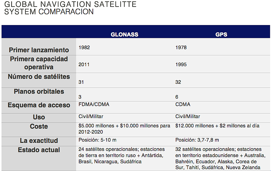
That historical background of the Cold War is at the origin of the two largest navigation systems we use today. The United States launched the Global Positioning System (GPS) project in the year 1973, and possibly in response, the Soviet Union presented its own positioning System (GLONASS) three years later. [ 1] It has been almost 45 years, and these two systems no longer serve Russians and Americans to try to get information on each other, but are collaborating and thus offering a more accurate and fast navigation system for consumers who buy a Smartphone or other electronic device. [2]
However, in order to achieve global coverage, both systems need not only satellites, but also ground stations strategically distributed around the world. For that purpose, the Russian Federal Space Agency, Roscosmos has erected stations for the GLONASS system in Russia, Antarctica and South Africa, as well as in the Western Hemisphere: it has four stations in Brazil and since April 2017 has one in Nicaragua, which by secrecy around its purpose has caused mistrust and suspicion in the United States [3] (USA, for its part, has ground stations for GPS in its territory and Australia, Argentina, United Kingdom, Bahrain, Ecuador, South Korea, Tahiti, South Africa and New Zealand).
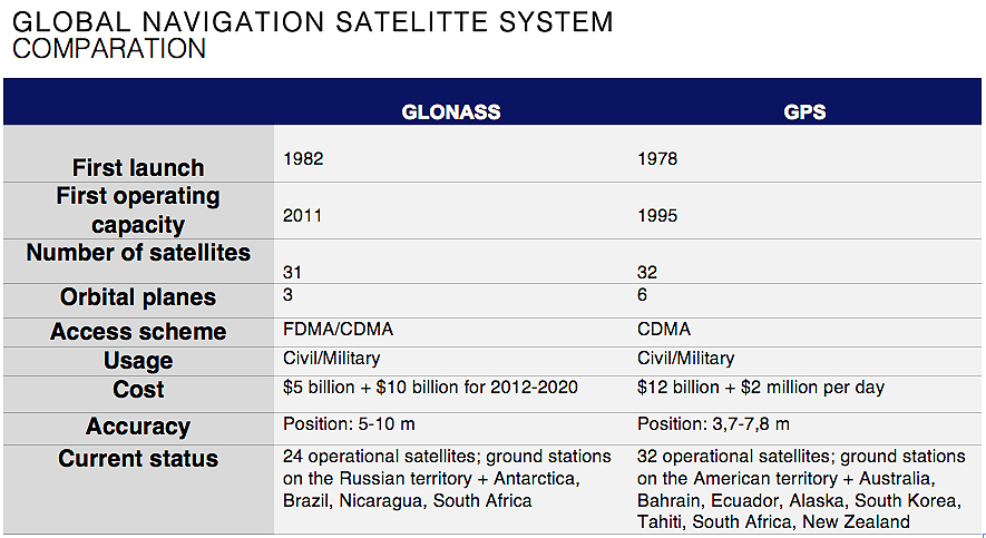
The Russian Global Satellite Navigation System (Globalnaya Navigatsionnaya Sputnikovaya Sputnikovaya sistema or GLONASS) is a positioning system operated by the Russian Aerospace Defence Forces. It consists of 28 satellites, allowing real-time positioning and speed data for the surface, sea and airborne objects around the world. [ 4] In principle GLONASS does not transmit any personally identifiable information; in fact, user devices only receive signals from satellites, without transmitting anything back. However, it was originally developed with military applications in mind and carries encrypted signals that are supposed to provide higher resolutions to authorized military users (same as the US GPS). [5]
 |
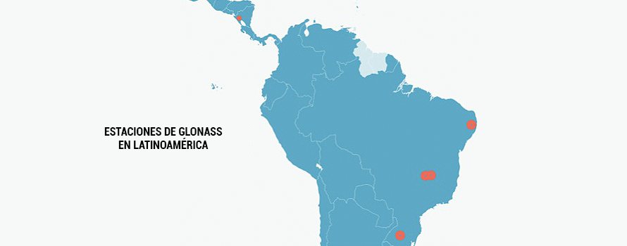
In Brazil, there are four Earth stations that are used to track signals from the GLONASS constellation. These stations serve as correction points in the Western hemisphere and help significantly improve the accuracy of navigational signals. Russia is in close and transparent collaboration with the Brazilian Space Agency (AEB), promoting research and development of the aerospace sector of this South American country. In 2013 the first station was installed, located on the campus of the University of Brasilia, which was also the first Russian station of that type abroad. It followed another station in the same place in 2014, and later, in 2016, a third was put in the Federal Institute of Sciences of the education and technology of Pernambuco, in Recife. The Russian Federal Space agency Roscosmos built its fourth Brazilian station on the territory of the Federal University of Santa Maria, in Rio Grande do Sul. In addition to fulfilling its main purpose of increasing accuracy and improving the performance of GLONASS, the facilities can be used by Brazilian scientists to carry out other types of scientific research. [6]
The level of transparency that surrounded the construction and then has prevailed in the management of the stations in Brazil is definitely not the same as the one applied in Managua, the capital of Nicaragua. There are several information that create doubts regarding the true use of the station. For starters, there is no information about the cost of the facilities or about the specialization of the staff. The fact that the station has been put at a short distance from the U.S. Embassy has given rise to conjecture about its use for phone-tapping and spying.
In addition, the vague replies from the representatives of Nicaragua and Roscosmos about the use of the station, have not managed to transmit confidence in the project. It is a "strategic project" for both Nicaragua and Russia, concluded Laureano Ortega, the son of the Nicaraguan president. Both countries claim to have very fluid and close cooperation in many areas, such as in health and development projects. However, none of those collaborations have materialized with such speed and dedication as this particular project. [7]
Given Russia's larger military presence in Nicaragua, empowered by the agreement that facilitates the mooring of Russian warships in Nicaragua announced by Russian Defense Minister Sergei Shoigu during his visit to the Central American country in February 2015, and specified also in the donation of 50 T-72B1 Russian tanks in 2016 and the increased movement of the Russian military personnel, it can be concluded that Russia clearly sees strategic importance in its presence in Nicaragua. [ 8] [ 9] This is all observed with suspicion from America. The head of South American Command, Kirt Tidd, warned in April that "the Russians are moving forward a disturbing attitude" in Nicaragua, which "impacts the stability of the region."
Without a doubt, when world powers like Russia or the United States act outside their territory, they are always guided by a combination of motivations. Strategic positioning is essential in the game of world politics. For this very reason, the aid that a country receives or the collaboration it can establish with a great power is often subject to political conditionality.
In this case, it is difficult to know for sure what is the purpose of the station in Nicaragua or even those of Brazil. At first glance, the objective seems neutral - offering higher quality navigation system and providing a different option to GPS -, but given the new importance that Russia is granting to its geopolitical capabilities, there is the possibility of more strategic use.
The thaw has caused the release of icebergs that may be a risk to navigation, but in Antarctica the geopolitics is partially frozen
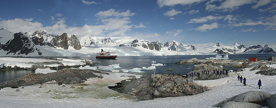
The increase of the temperatures is opening the Arctic to the commercial routes and to the dispute between countries for the future control of the riches of its subsoil. In Antarctica, with lower temperatures and a slower thaw, what is under the white mantle is not an ocean, but a continent away from the navigation lines and the direct interests of the great powers. There are reasons for the main international actors to prefer to continue leaving in the fridge all claims about the South Pole.
ARTICLE / Alona Sainetska [English version].
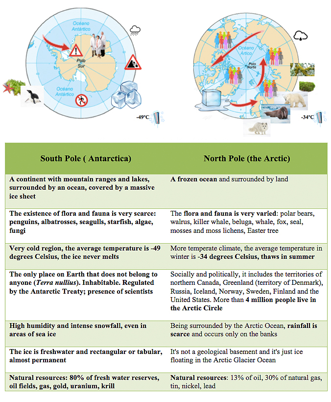
Antarctica is a continent with mountain ranges and lakes, surrounded by an ocean and with a total area of 14 million square kilometers. It is often compared to the Arctic which is, instead, an icy sea surrounded by land. In the north of the Arctic Circle live about 4 million people. In contrast, the Antarctica, with its average of -49° C of temperature, is absolutely uninhabitable and is considered today as a natural sanctuary that attracts the attention of numerous countries from all over the world.
Even though the South Pole does not present, at a first glimpse, any important elements for a conflict in the global, international system, the sovereignty of its territory has never been exempt from disputes and territorial claims by countries such as the United Kingdom, Australia, New Zealand, Norway, France, Argentina and Chile. Although lately they were left in abeyance, the claims of those countries do not interfere with others, except in the case of Argentina and Chile, whose claims were made on the parts of the land that have already been requested totally or partially by England.
In this context there has occurred a transcendental coincidence of interests among the aforementioned countries which also spread to the non-claiming superpowers, as was the case of the United States and the USSR. Both showed little desire to convert the continent and the maritime space into an object of political-military clashes. This fact facilitated a lot the negotiations about the future legal status that would have "the frozen continent".
The first attempt to establish a special legal regime for Antarctica was the initiative of the United States, in 1948. However, this idea failed while clashing with the opposition of countries that wished to expand their sovereignty to the territories of Antarctica. Only two years later, when the USSR announced that it would not accept any agreement on Antarctica in which it was not represented, could the continent arouse interest of the great powers once again.
Facing the need of reaching a consensus and as a result of the enormous efforts of the world scientific community, a climate of cooperation and international dialogue on Antarctica was born. This allowed free access of scientists of any nationality to the continent, as well as the exchange of the results of their investigations.
This new context led to the signature of the Treaty on Antarctica (ATS), on December 1, 1959 , which entered into force on June 23, 1961. Any possible modification, by majority, was postponed until a conference scheduled for 30 years after its enforcement. However, when 1991 arrived, there were no changes applied and, what is even more, the safeguards were added.
In the TA, the member-countries committed themselves to recognize a special legal regime of Antarctica, giving it a status of "terra nullius". In addition, there was established a demilitarization of the Antarctic continent, which reserved the frozen space exclusively for peaceful purposes and prohibited the foundation of military instructions.
On the other hand, it proclaimed the freezing of all claims of territorial sovereignty over Antarctica, not allowing either making new claims or expanding those previously made during the period of validity of the treaty.
In the same way, there was originated a right to appoint observers in order to ensure fulfillment of the objectives of the treaty and, additionally, there were organized some periodic meetings for both the original signatory states and those being assigned a consultative function for carrying out important scientific missions in Antarctica.
Scientific and economic potential
In 1991, there were some additional efforts made in the conservation of the frozen giant. In order to respond to issues such as climate change and the need to protect the special ecosystem that the continent represented, the so-called "complementary" protocol to the AT on environmental protection was signed in Madrid. The requisite for its entry into force was the obligation to be ratified by all the Antarctic Treaty consultative members.
It put under prohibition any exploitation of mineral resources, except those carried for scientific purposes. This restriction could only be lifted by unanimous agreement and kept the continent away from possible plunder of its great natural resources. Antarctica thus became a unique place in the world where the coexistence between man and nature could be possible and long-lasting.
However, the last decades supposed many strategic changes that have caused serious doubts and concerns regarding the effectiveness of the TA. Antarctica's scientific and economic potential, together with its enormous biodiversity and richness in natural resources, have greatly increased its importance. The greater interaction and interdependence of the numerous national, international and transnational actors that form the world community has also multiplied the desire to influence and participate, in different ways, in the pursuit of particular interests in this area of the world.
Thus, not only there are projects aimed to guarantee environmental conditions, such as discussion on the creation of a large area of natural preservation in the Ross Sea, but also some controversial initiatives in order to take advantage of Antarctic resources. One example could be a recent suggestion of the Arab Emirates to tow icebergs from the masses of Antarctic ice towards the Middle East, in order to combat drought and meet the needs of its population (Antarctica contains 80% of the planet's freshwater reserves).
These icebergs, on the other side, can present a tremendous threat to navigation and commerce, especially in the case of the large ones, such as Larsen C, which is every day increasingly closer to a collapse. The consequences may be tragic - a huge iceberg of 5,800 square kilometers left adrift.
 |
Countries with different weight
Although, due to the disadvantages resulting from the remoteness of the continent and its harsh and unfavourable conditions, a possible exploitation of Antarctica is not foreseen for the short run and remains now more hypothetical rather than real, there is still a risk of future deployment of economic activity in the Antarctic region worldwide.
The latter will depend on international alignments that may arise.
The alignments in relation to the Antarctica follow the administration structure imposed by the Treaty, which includes three categories of members:
-
The original signatories (Argentina, Australia, Belgium, Chile, France, Japan, New Zealand, Norway, South African Republic, Soviet Union, Great Britain and the United States) participating in a full right in the consultative meetings of the TA where decisions are made.
-
Those States that wish to join and, having developed important scientific activities, obtain the consent to participate in the Consultative meetings (for example: Poland, Germany, India, Brazil, China and Uruguay).
-
Finally, the States that adhere, but, because of not carrying out a significant scientific activity, cannot participate in decision-making (Czechoslovakia, Cuba, Hungary, Bulgaria, Peru, Italy, New Guinea, Spain, Sweden, the Netherlands, Denmark, Romania and Finland).
A similar situation of collision of interests among the international actors is evident at the opposite pole of the Earth, the Arctic. Its climatic conditions have much warmer temperatures that allow the melting of its sensitive layer of ice. So, the thaw caused by the global warming makes the Arctic's energy wealth more and more accessible (it is estimated that it harbours 13% of the oil and 30% of the natural gas that remains in the planet). As a direct consequence of that, the struggle for gaining rights to exploit it is being intensified between countries such as, Denmark, Canada, the United States, Norway and Russia.
On the other hand there is China, for which the thawing has a lot of positive consequences, such as the opening of new inter-oceanic navigation routes between northern Europe and much shorter Shanghai, or easier access to mining areas like Greenland.
In light of the above considerations (the abundance of essential minerals in technology, the opening of new routes or maritime transport and the fact that the lands located in the Arctic Circle are habitable, along with benevolent conditions and easier access), it is very likely that the Arctic may be integrated into the world economic structure much sooner than Antarctica.
Russia's GLONASS positioning system has placed ground stations in Brazil and Nicaragua; the Brazilian ones are accessible, but the Nicaraguan one is open to conjecture.
At a time when Russia has declared its interest in having military installations in the Caribbean again, the opening of a Russian station in Managua's area has raised some suspicions. Roscosmos, the Russian space agency, has opened four stations in Brazil, managed with transparency and easy access; in contrast, the one it has built in Nicaragua is shrouded in secrecy. The little that is known about the Nicaraguan station, strangely larger than the others, contrasts with how openly data can be collected about the Brazilian ones.

article / Jakub Hodek [English version].
It is well known that information is power. The more information one has and manages, the more power one enjoys. This approach should be taken when examining the station facilities that support the Russian satellite navigation system and their construction in close proximity to the United States. Of course, we are no longer in the Cold War period, but some traumas of those old days can perhaps help us to better understand the cautious position of the United States and the importance Russia sees in having its facilities in Brazil and especially in Nicaragua.
That historical background of the Cold War is at the origin of the two major navigation systems we use today. The United States launched the Global Positioning System (GPS) project in 1973, and possibly in response, the Soviet Union introduced its own positioning system (GLONASS) three years later. [1] Nearly 45 years have passed, and these two systems are no longer serving as a means for Russians and Americans to try to obtain information about the opposing side, but are collaborating and thus providing a more accurate and faster navigation system for consumers who purchase a smartphone or other electronic device. [2]
However, to achieve global coverage both systems need not only satellites, but also ground stations strategically located around the world. With that purpose, Russian Federal Space Agency Roscosmos has erected stations for the GLONASS system in Russia, Antarctica and South Africa, as well as in the Western Hemisphere: it already has four stations in Brazil and since April 2017 it has one in Nicaragua, which due to the secrecy surrounding its function has caused distrust and suspicion in the United States [3] (USA, for its part, has GPS ground stations in its territory and in Australia, Argentina, United Kingdom, Bahrain, Ecuador, South Korea, Tahiti, South Africa and New Zealand).
The Russian Global Navigation Satellite System(Globalnaya Navigatsionnaya Sputnikovaya Sputnikovaya Sistema or GLONASS) is a positioning system operated by the Russian Aerospace Defense Forces. It consists of 28 satellites, allowing real-time positioning and speed data for surface, sea and airborne objects around the world. [ 4] In principle GLONASS does not transmit any identification information staff; in fact, user devices only receive signals from the satellites, without transmitting anything back. However, it was originally developed with military applications in mind and carries encrypted signals that are supposed to provide higher resolutions to authorized military users (same the US GPS). [5]
In Brazil, there are four ground stations used to track signals from the GLONASS constellation. These stations serve as correction points in the western hemisphere and help to significantly improve the accuracy of navigation signals. Russia is in close and transparent partnership with the Brazilian space agency (AEB), promoting the research and development of the South American country's aerospace sector.
 |
In 2013, the first station was installed, located at campus of the University of Brasilia, which was also the first Russian station of that subject abroad. Another station followed at the same location in 2014, and later, in 2016, a third one was placed at the high school Federal Science Education and Technology of Pernambuco, in Recife. The Russian Federal Space Agency Roscosmos built its fourth Brazilian station on the territory of the Federal University of Santa Maria, in Rio Grande do Sul. In addition to fulfilling its main purpose of increasing the accuracy and improving the performance of GLONASS, the facility can be used by Brazilian scientists to carry out other types of scientific research . [6]
The level of transparency that surrounded the construction and then prevailed in the management of the stations in Brazil is definitely not the same applied to the one opened in Managua, the capital of Nicaragua. There are several pieces of information that sow doubts regarding the real use of the station. To begin with, there is no information on the cost of the facilities or on the specialization of the staff. The fact that it has been placed a short distance from the U.S. Embassy has given rise to conjecture about its use for eavesdropping and espionage.
In addition, vague answers from representatives of Nicaragua and Roscosmos about the use of the station have failed to convey confidence about project. It is a "strategicproject " for both Nicaragua and Russia, concluded Laureano Ortega, the son of the Nicaraguan president. Both countries claim to have a very fluid and close cooperation in many spheres, such as in projects related to health and development, however none of them have materialized with such speed and dedication. [7]
Given Russia's increased military presence in Nicaragua, empowered by the agreement facilitating the docking of Russian warships in Nicaragua announced by Russian Defense Minister Sergei Shoigu during his visit to the Central American country in February 2015, and also concretized in the donation of 50 Russian T-72B1 tanks in 2016 and the increasing movement of the Russian military staff , it can be concluded that Russia clearly sees strategic importance in its presence in Nicaragua. [ 8] [ 9] All this is viewed with suspicion from the U.S. The head of the U.S. Southern Command, Kirt Tidd, warned in April that "the Russians are pursuing an unsettling posture" in Nicaragua, which "impacts the stability of the region."
Undoubtedly, when world powers such as Russia or the United States act outside their territory, they are always guided by a combination of motivations. Strategic moves are essential in the game of world politics. For this very reason, the financial aid that a country receives or the partnership that it can establish with a great power is often subject to political conditionality. In this case, it is difficult to know for sure what exactly is the goal of the station in Nicaragua or even those in Brazil. At first glance, the goal seems neutral-offering higher quality of navigation system and providing a different option to GPS-but given the new value Russia is placing on its geopolitical capabilities, there is the possibility of a more strategic use.
Melting ice has caused icebergs to break off and pose a risk to navigation, but in Antarctica, geopolitics is partially frozen.
Rising temperatures are opening up the Arctic to trade routes and to competition between countries for future control of its subsoil riches. In Antarctica, with lower temperatures and slower melting, what lies beneath the white mantle is not an ocean, but a continent far from shipping lanes and the direct interests of major powers. There are reasons why major international actors prefer to keep any claims about the South Pole on the fridge.

ARTICLE / Alona Sainetska [English version].
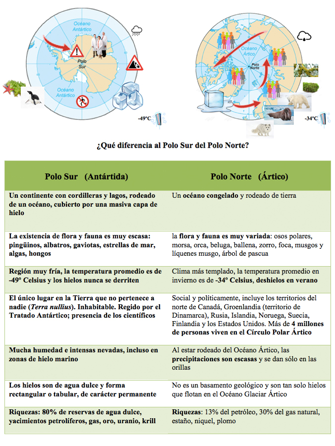
Antarctica is a continent with mountain ranges and lakes, surrounded by an ocean and with a total area of 14 million square kilometres. Because of its location at opposite poles, Antarctica is often compared to the ice mass of the Arctic Ocean, which is instead a sea ice surrounded by land. In those northern parts of Eurasia and America, north of the Arctic Circle parallel, about 4 million people live. In contrast, Antarctica, with its average temperature of -49°C, is absolutely uninhabitable and is today considered a natural sanctuary that attracts the attention of many countries in the international community.
Despite not presenting, at first sight, significant elements of conflict in the global system as a whole, the sovereignty of its territory has never been free of disputes and territorial claims by countries such as the United Kingdom, Australia, New Zealand, Norway, France, Argentina and Chile. Although later left at Fail, the claims of these countries did not interfere with each other, except in the case of Argentina and Chile, whose claims were over land with higher concentrations of Antarctic shrimp or krill and which had already been claimed in whole or in part by England.
The interests of the aforementioned countries and also those of the non-claimant superpowers, such as the United States and the USSR, which showed little desire to turn both the continent and the maritime space into an object of political-military confrontation, coincided in a transcendental way on this issue. This fact greatly facilitated negotiations on the future legal status of "the frozen continent".
The first attempt to establish a special legal regime for Antarctica was made by the United States in 1948. However, this idea failed when confronted with the civil service examination of countries wishing to extend their sovereignty to Antarctic territories. It was only two years later that the continent again aroused the interest of the major powers when the USSR announced that it would not accept any agreement on Antarctica in which it was not represented.
Faced with the need to reach a consensus, and as a result of the enormous efforts of the world's academic community , a climate of cooperation and international dialogue on Antarctica was born, which allowed free access to the continent for scientists of any nationality, as well as the exchange of the results of their research. This new context led to the Antarctic Treaty (AT), which entered into force on 23 June 1961, signature on 1 December 1959. Any possible modification, by majority vote, was postponed until a lecture planned for 30 years after its entry into force; when 1991 arrived, not only were no changes implemented, but safeguards were added.
In the AT, the countries involved undertook to recognise a special legal regime for Antarctica, giving it the status of "terra nullius". It also provided for the demilitarisation of the Antarctic continent, which reserved the frozen space exclusively for peaceful purposes and prohibited the establishment of instructions military.
On the other hand, it proclaimed the freezing of all claims to territorial sovereignty over Antarctica, and during the period of validity of the treaty no new claims could be made or those previously made extended.
It also established the right to appoint observers to ensure compliance with the objectives of the treaty and provided for periodic meetings of the original signatory states to the AT, plus other states granted consultative status for carrying out important scientific missions in Antarctica.
Scientific and economic potential
In 1991, a further step was taken in the conservation of the frozen giant. goal With the aim of responding to issues such as climate change and the need to protect the special ecosystem that the continent represented, the so-called protocol "complementary" to the AT on environmental protection was signed in Madrid. The condition for its entrance entry into force was that it be ratified by all the consultative members of the Antarctic Treaty. It prohibited any subject exploitation of mineral resources other than for scientific purposes. This ban could only be lifted by a unanimous agreement and it kept the continent away from possible plundering of its vast natural resources. Antarctica thus became a unique place in the world for the coexistence of man and nature.
However, recent decades have introduced many strategic changes that have given rise to serious doubts and concerns about the effectiveness of the AT. Its scientific and economic potential, together with its enormous biodiversity and wealth of natural resources, have greatly increased Antarctica's importance. The increased interaction and interdependence of the different national, international and transnational actors that make up the global community has also multiplied the desire to influence and participate, in different ways, in the pursuit of particular interests in this part of the world.
Thus, alongside projects to guarantee environmental conditions, such as the discussion on the creation of a large natural preservation area in the Ross Sea, controversial initiatives are sometimes launched to make use of Antarctic resources, such as the one suggested by the United Arab Emirates to tow icebergs that break off the Antarctic ice mass to the Middle East in order to combat drought and meet the needs of its population (Antarctica contains 80% of the planet's freshwater reserves).
Such icebergs, on the other hand, can pose a threat to shipping and trade, especially if they are large, as may be the case with the Larsen C ice shelf, which is increasingly close to collapse, leaving a huge 5,800 square kilometre iceberg adrift.
 |
Countries with different weights
Although a possible exploitation of Antarctica is not envisaged in the short or medium term deadline and remains hypothetical for the time being, thanks to the disadvantages resulting from the continent's remoteness and its harsh and unfavourable conditions, there is a risk of a future deployment of economic activity in the Antarctic region on a global scale. The latter will depend on international alignments that may emerge.
The alignments in relation to Antarctica take their cue from the management structure imposed by the Treaty, which includes three categories of membership:
-
The original signatories (Argentina, Australia, Belgium, Chile, France, Japan, New Zealand, Norway, South Africa, the Soviet Union, Great Britain and the United States) which participate as of right in the consultative meetings of the TA where decisions are taken ( plenary session of the Executive Council ).
-
Those States wishing to join and which, having developed significant scientific activities, obtain consent to participate in the Consultative Meetings (e.g. Poland, Germany, India, Brazil, China and Uruguay).
-
States that join, but which, because they do not carry out significant scientific activity, cannot participate in decision-making (Czechoslovakia, Cuba, Hungary, Bulgaria, Peru, Italy, New Guinea, Spain, Sweden, the Netherlands, Denmark, Romania and Finland).
status A similar collision of interests on the part of international actors is taking place at the opposite pole of the Earth, the Arctic. Its climatic conditions are much warmer, allowing its sensitive ice sheet to thaw. Thus, global warming-induced thawing makes the Arctic's energy wealth increasingly accessible (it is estimated to hold 13 per cent of the world's remaining oil and 30 per cent of its remaining natural gas) and thus intensifies the battle for the rights to exploit it by countries such as Denmark, Canada, the United States, Norway and Russia. On the other side is China, for whom the thaw has multiple positive consequences, such as the opening of a new, much shorter inter-oceanic shipping route between northern Europe and Shanghai, or easy access to mining in areas such as Greenland.
The abundance of key minerals in technology, the opening of new shipping routes, and the fact that the land around the Arctic Circle is habitable, with benevolent conditions and increasingly easy access, make it highly likely that the Arctic will be integrated into the global economic structure sooner than the Antarctic.

