In the picture
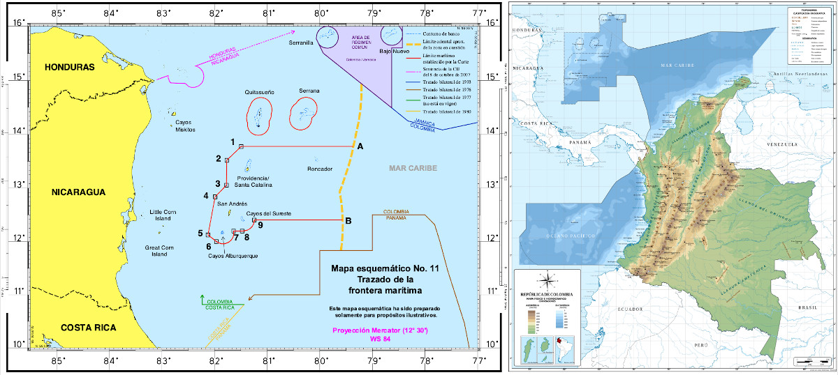
In the map on the left, the red line is the delimitation established by the ICJ in 2012; the yellow line marks the original request made by Nicaragua; the map on the right indicates the traditional Colombian maritime sovereignty [ICJ and Gov.Col.]
report AMERICAN REGIONAL SECURITY, SRA 2023 /PDF version from article
° Bogota does not recognize the 2012 ruling which, although it ratified its sovereignty over the islands and keys in dispute, restricted its national territorial waters.
° In April 2022 the ICJ said that Colombia was violating Nicaragua's sovereign rights with its patrols and requested that the Colombian fishing intrusion cease.
° The different measurement on which Nicaragua bases its demands and the ambiguous interpretation of some ICJ provisions prolongs the uneasiness in the islands.
The islands of San Andres and Providencia (and Santa Catalina, next to the latter) live from tourism rather than fishing. The last problems of air connection with the continental territory of Colombia are the main concern of the archipelago, which is located in plenary session of the Executive Council Caribbean Sea, closer to Nicaragua than to the South American coast. In any case, fishing provides the livelihood of part of the population and the long dispute at the International Court of Justice (ICJ) in The Hague on the extent of Colombian sovereignty over these islands and the nearby keys (Alburquerque, Roncador, Serrana, Bajo Nuevo, Quitasueño and Serranilla) complicate an activity that Colombian patrol boats find difficult to guarantee.
On November 30, 2022, several men presumably of Nicaraguan nationality, armed with AK-47 rifles, assaulted a fishing boat in the early hours of the morning in an area near Quitasueño Key, which the assailants apparently used as a base for their fishing robberies. Precisely the 2012 ruling left the keys of Quitasueño and Serrana isolated, surrounded by Nicaraguan territorial waters, although Colombian jurists interpret that a corridor of sovereign waters could be established to connect them with the rest of the Colombian Caribbean area .
Incidents, although not daily, are repeated. A few months earlier, Providencia fishermen were harassed in the middle of their work, while the Colombian Coast Guard detected illegal Nicaraguan fishing. On October 29, 2021, the seizure of more than one ton of fish from four Nicaraguan vessels was announced.
Petro vs Ortega
The procedure ongoing at the ICJ, which held its initial public hearing in December 2022, seeks to settle the delimitation of each country's maritime jurisdiction. In 2013 Nicaragua filed a claim to extend its sovereignty beyond 200 nautical miles, alleging that its continental shelf has a greater extension. It asserts that its request is covered by both the provisions of the United Nations Convention on the Law of the Sea and customary law. Colombia denies the latter and also recalls that it is not a signatory to the Convention, so it is not bound by it.
Colombian President Gustavo Petro has been uncomfortably welcoming this dispute. When he was still candidate to the presidency, Petro was blaming previous governments for not having known how to defend the sovereignty over the entire maritime area that before 2012 was internationally recognized to Colombia. Thus, in April 2022, the candidate of the Historical Pact affirmed: "The Court of the Hague prohibits the fishing activity of the Raizales in the sea that was already excluded from our Nation. And it prohibits us all activity as a country in that sea that was ours. Uribism made Colombia lose sovereignty", thus blaming the government of Alvaro Uribe for the result in the Court and not the plaintiff country. Already as president, in September he also blamed his four predecessors, but soon he had to incorporate the issue in his government management to assert Colombian national interests himself and began to direct his attacks against Nicaraguan President Daniel Ortega. "Ortega is taking the sea away from us," he said in November.
The Colombian left was confident that upon coming to power it could establish a constructive dialogue with Ortega regarding the sovereignty disputes over its adjacent territorial waters in the Caribbean, but when Petro has finally reached the presidency it happens that the Nicaraguan regime has advanced so far in its profile of grotesque dictatorship that it makes a rapprochement difficult. In the entrenched status in which Ortega finds himself, any possible nationalist advance constitutes a plank of salvation before his own public opinion.
Historical heritage
When one looks at the map of Colombia's maritime extension, one is surprised by its amplitude and its shape: how its waters are attenuated by Panama's. The explanation lies in the territorial structure of the Spanish Empire. The explanation lies in the territorial structure of the Spanish Empire: on the one hand, the seat of the Viceroyalty of New Granada, which was in Bogota, was assigned islands that were close to Central America, a politically less important territory because it depended on the Viceroyalty of New Spain, based in Mexico City; on the other hand, Panama was governed from Bogota until, almost a century after the Spanish-American independences, it achieved its own independence.
Over time, Colombia has agreed with several countries on its maritime delimitation, such as Panama, Costa Rica and Honduras, as well as with Jamaica, with whom it established a common regime area around the cays of Serranilla and Bajo Nuevo. However, the greatest friction has historically been with Nicaragua, since the archipelago of San Andres and Providencia is located 150 nautical miles from the Nicaraguan coast (and almost 500 miles from the northwest coast of Colombia), in collision with the usual right of sovereignty over 200 miles.