The piece of the month of January 2021
THE VISION OF THE WORLD IN THE AGE average. THE WORLD MAP OF THE BLESSED NAVARRO
Carmen Jusué Simonena
UNED Pamplona
Professor Sandra Sáenz-López, a great connoisseur of cartography in the Middle Ages average, mentions that when confronted with a medieval map we must erase the preconceived idea of a map, or at least be receptive to new cartographic images that may be antagonistic to our modern definitions. Only then will we be able to recognise a medieval map and understand what it represents and what its usefulness was. The first medieval meaning of map is that of image. According to the definition found in Ebstorf's mappamundi (around 1300), it is "mappa dicitur forma. Inde mappamundi id est forma mundi" (map means form. Therefore, a mappamundi is a form of the world).
The enormous visual richness and the aesthetic sense with which the numerous images incorporated in medieval maps are made, continues Sáenz-López, justify this cartography as an artistic manifestation. The maps of the Middle Ages average not only reproduce the world in its physical sense, that is to say, the Earth, since the numerous texts and illustrations they incorporate show it from a wider definition, which we could call 'encyclopaedic', since it also includes scientific, historical or religious questions.
For the Romans, Galicia was the end of the known world, and thinkers such as Hugo of Saint Victor affirmed that time had begun in the East - where Paradise was located - and that the course of humanity was moving towards the West, where the events of the end of time would take place.
In the miniatures illustrating the works of Isidore of Seville, Bede the Venerable and, above all, Beatus of Liébana, the world map offered two clearly separated spaces, as Professor García de Cortázar mentions: that of the earth, circular and ordered, and that of the seas, report and chaotic. The seas were for the people of the time spaces full of threats, especially the Atlantic Ocean, a scene of darkness and fear, of islands that appeared and disappeared, of huge and strange animals, even, according to Irish tradition, the place of purgatory.
Apart from this murky sea, the terrestrial spaces represented on the maps of those centuries showed a symbolic hierarchy. At the centre of the world map were Rome or Jerusalem, a sign of the importance of these two cities, and around them Europe, separated from the lands of Asia by the river Tanis and from those of Africa by the Mediterranean. Outside this centre were imaginary countries, such as those of Gog and Magog. Six centuries before Christ, Ezekiel had mentioned them in his prophecies, and medieval Europeans supposed them to be inhabited by barbarous, ferocious peoples and monstrous creatures. Such were the so-called "T" maps, because two lines resembling that capital letter separated the three then known parts of the world: Europe, Asia and Africa. Together with the aforementioned Jerusalem and Rome, it is very common to see the signalling of Santiago de Compostela, as a place that must have been familiar to the authors of several medieval maps.
According to the Bible, four rivers emanated from the Paradise source - Tigris, Euphrates, Pheon and Geon - and although not all maps respect the same issue or identification, these are the most reiterated. These rivers, according to the medieval geographical conception, crossed the border of Paradise and irrigated the world. While there was no doubt in the identification of the Tigris and Euphrates, the recognition of the Pheon and Geon rivers generated several suggestions, so that the Pheon was mostly related to the Ganges, although the Danube and Indus were also suggested; and the Geon, mostly to the Nile.
Among the monstrous creatures depicted on the world maps were the scyapods, also known as monosceles, mythological creatures with only one oversized leg and foot. Their name means 'foot-shadow' and is due to their habit of raising their legs like an umbrella to provide shade. Scylax of Carianda speaks of them in the 6th century BC, locating them in India, a place where Pliny the Elder also places them in the 1st century AD in his Naturalis historia. Centuries later, with the advent of Christianity, the legend survives to such an extent that St. Augustine, in the 4th century, gives a brief description of them: "They also say that there is a nation in which they have only one leg and do not bend the knee and are of admirable speed, whom they call sciopods".
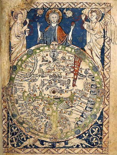
World map from the Westminster AbbeyPsalter of 1265. Small map, about 9.5 cm high, now in the British Library.
The world maps also make reference letter to the imaginary countries of Gog and Magog, so that Magog is the name of a nation, land or kingdom at the ends of the known world, which is mentioned in conjunction with Gog, the name of its ruler, as "Gog and Magog". This country is originally mentioned in the Book of Ezekiel; it is a land or region connected with nations north of Israel, the place of origin of a devastating invasion. In the New Testament it appears in Revelation, so that Magog, along with Gog, are nations found at the four ends of the earth. From these texts, Magog, with its ruler Gog, are associated with catastrophic events related to the end of the world, in which they represent the archetypal enemies of the chosen people.
From the mid-12th century onwards, Europeans became increasingly able to distinguish between physical reality and symbolic representation. At the same time, the expansion of the space travelled by travellers made it possible to bring cartography into line with real geography. This resulted in the 13th century in works such as Ebstorf's mapamundi, the largest map of the world produced in the Middle Ages average. The concept of the visual atlas - the representation of history, technology, art and other aspects against a geographical background - is a recent one, but without being so named, mapamundis containing much more than merely geographical information and displaying it graphically have been produced for centuries. Two good examples are the so-called Hereford and Ebstorf world maps, which are also the largest medieval maps in the world.
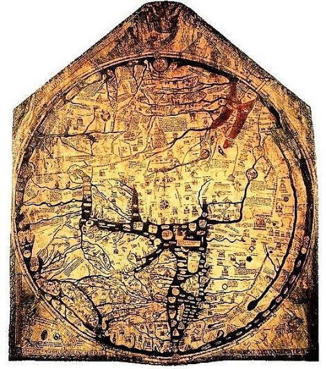
Hereford world map of 1285. It measures 132 x cm, drawn on a single sheet of parchment with black ink and some touches of red, green, gold and blue. It depicts 420 cities, 15 biblical events, 33 animals and plants, 32 people, and five scenes from classical mythology.
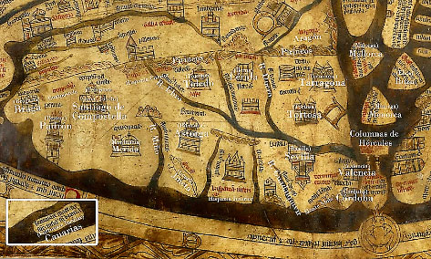
Detail of the Hereford World Map. The Iberian Peninsula, the Balearic Islands and the Canary Islands are drawn on the edge of the lower part. Other details include the temple of Santiago de Compostela. file from Wikimedia Commons.
The maps of the Blessed
At the end of the 8th century, Beato de Liébana composed the Commentary on the Apocalypse in the monastery of San Martín de Turieno. Although it has not reached us in its original state, this work is known thanks to the numerous copies made in the following centuries, which have made it a masterpiece of medieval art. The Beatos, as they are all known, are especially interesting for their expressive illustrations, among them the world map that sample the evangelization of the apostles around the world. This image, already present in the first manuscript, underwent an interesting evolution as the Commentary on the Apocalypse was copied and edited between the X 13th centuries. The main function of the map is not to represent the world cartographically, but to serve as an illustration of the diaspora of the apostles. Fourteen mappamundi are preserved today, to which can be added other cartographic works derived from or related to them.
We will highlight some examples, such as the world map in the manuscript preserved in the cathedral of Burgo de Osma, which is not only one of the best-known maps in the Beatus cartographic series, but also one of the most interesting artistic illustrations for understanding early medieval religious geography. It was possibly made in Sahagún in 1086, and in it Jerusalem, India, paradise on earth, the Pyrenees, Santiago de Compostela, the Tower of Hercules, the Mediterranean and the unknown land under the Red Sea, represented by strange-looking beings, can be seen quite easily.
In all these maps the world is circular in shape; the Earthly Paradise, located in Asia, in the upper part of the map, illustrated with the four rivers (Tigris, Euphrates, Geon and Pheon); Europe and Africa in the lower part, separated by the Mediterranean Sea; and, finally, the heads of the twelve apostles scattered all over the world, although they do not always appear in the place assigned in the text, but rather where they were martyred or where their remains are venerated. For example, St James the Greater appears in Galicia(Galicia) and not in Spain(Spania).
World map of the Beatus of Liébana of Burgo de Osma, 1086 (copy of 1203). Orientated with the East at the top, it contains images of the twelve apostles.
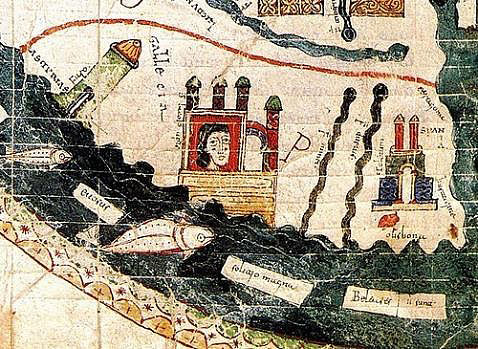
Map of the Beatus of Burgo de Osma of 1086. Detail of Hispania and Santiago
inside his temple.
The purpose of the maps of the Blessed is alluded to in the text of the Commentary on the Apocalypse itself: to illustrate the Missio apostolorum, that is, the evangelisation of the apostles to all nations, following Christ's command. Thus, for example, according to Matthew (16:15), after his Resurrection Christ appeared to the apostles and said to them: "Go into all the world and preach the gospel to every creature". In the Commentary on the Apocalypse by Beato de Liébana, in the text that precedes the map, he assigns each of the apostles a place to evangelise. The map therefore represents apostolic evangelisation, and for this purpose it is included in the Commentary on the Apocalypse.
The Beatus of Navarre
Among the various copies of the Beatus, we will highlight the so-called Beatus of Navarre, also known as the Beatus Gascon, a codex which, both for its writing and its images, has been considered to be of Spanish origin. We know, thanks to the information given about it by Fr. José Moret, that in the 17th century there was a Beatus at Library Services in Pamplona Cathedral, which disappeared at an unknown date. Coincidentally, in 1897, a manuscript of the same characteristics was sold to the Library Services National of France. In a subsequent study it was discovered that this Beatus had a privilege of Charles III the Noble dated 4 May 1389 attached to the inside of one of its covers, which clears up any doubts as to its coincidence with the Beatus that existed in Pamplona. We have no information as to how it reached Pamplona Cathedral.
Its provenance is unknown, as some experts believe it to have originated in a monastery in Navarre or the French Pyrenees, while others associate it with the area around Silos, although the special treatment given in its world map to the city of Astorga, which is the only one indicated as being inscribed on a cogwheel, could also suggest that it was possibly commissioned from a scriptorium in Leon or Spanish for a church in that diocese.
Along these lines, the opinion of the professors Elisa Ruiz García and Soledad de Silva y Verástegui, in their Study Book accompanying the facsimile of the Beatus of Navarre published by Millennium Liber, on the possibility that it may have been created in a Cistercian monastery, is very interesting, given that it seems that the Commentary on the Apocalypse was a book of special interest to this order, since of the last eight or ten late Beatus, dated at the end of the 12th and beginning of the 13th century, five of them are related to Cistercian monasteries.
It is therefore a copy of the Commentary on the Apocalypse by Beatus of Liébana, dated in the 12th century, in which both the text and its magnificent illustrations make it the last Beatus corresponding to the oldest pictorial version of the original codex and also the last of the second textual version, the one considered to date from the year 784. Its subject handwriting, Carolinian from the transition to Gothic, of great quality, and its multiple miniatures, whose style corresponds to the Romanesque plenary session of the Executive Council, make this manuscript of great interest.
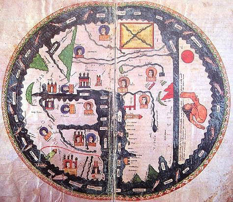
The representation on a double page (fol. 24v-25) of the map of the world or mappamundi is one of the expressly important illustrations in the text. After having commented on the names of the apostles and the lands to be evangelised by each one, the author invokes the didactic efficacy of the image. This map, like its predecessors, reflects the ancient Isidorean conception of the world as circular, surrounded by the ocean; the earth is divided there by seas and rivers into three parts, namely the three continents then known: Asia, Europe and Africa, according to a diagram that inscribes in the text of the orb a T, the initial of Terrarum.
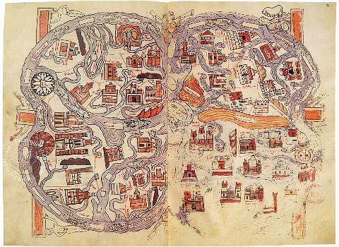
Map of the Beatus of Navarre from the 12th century.
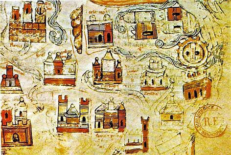
World map of the Beatus of Navarre from the 12th century, detail of the area of Europe.
Compared to other maps, this mappamundi is characterised by its extravagant cosmography, as Professor Moralejo has already observed, who sees in his testimony a simple curiosity. However, the map of the Beatus of Navarre is closely related to the Beatus of Osma, which precedes it by a century, echoing several novelties introduced by it. One of the most original is the representation of the scyapod, inhabitant of the torrid unknown land, located in the southern hemisphere, which is shadowed by its singular and gigantic foot, but which in the Navarrese Beatus was placed outside its usual place.
It also includes other motifs included in the previous ones, such as the representation of the image of the sun, of buildings to represent cities, the presence of the lighthouse of Alexandria or the dissemination of the islands throughout the oceanic orb; an added feature, which has its origin in cosmographic traditions other than those of the Commentary on the Apocalypse which, according to Professor Moralejo, is the personification of the winds that the Beato Navarro shares with the mural map of San Pedro de Rocas (Esgos, Ourense), from the 12th century. It also has another element that has attracted the attention of several researchers, such as the importance given to Asturica among the rare recognisable toponyms, i.e. Astorga, represented with a large cogwheel, which could be an indication of the true origin of the manuscript, given its uncertain provenance.
In final, as S. Moralejo points out, it is a mappamundi similar, in certain aspects, to that contained in other Beatus, but characterised by its crazy cosmography that reduces its testimony to mere curiosity. It follows different earlier models, but its copyists, who must not have understood anything about geography, reproduced names and locations in a capricious manner, so that it can be said that, as far as the location of territories and cities is concerned, nothing is in its place.
SOURCES AND BIBLIOGRAPHY
DE SILVA Y VERÁSTEGUI, S., "Le Beatus navarrais de Paris (Bibl. Nat., nouv. acq. lat. 1366)", Cahiers de civilisation médiévale, 40, nº 159, 1997, pp. 215-232.
DE SILVA Y VERÁSTEGUI, S., "Los Beatos en La Rioja", Príncipe de Viana, year 55, no. 202, 1994, pp. 249-272.
GARCÍA DE CORTÁZAR, J. A., Los viajeros medievales, Historia hoy, Madrid, Santillana, 1996.
MORALEJO, S., "El mapa de la diáspora apostólica en San Pedro de Rocas: notas para su interpretación y filiación en la tradición cartográfica de los Beatos", Compostellanum: revista de la Archidiócesis de Santiago de Compostela, 31, n.º 3-4, 1986, pp. 315-340.
RUBIO TOVAR, J., "Viajes, mapas y literatura en la España medieval", Viajes y viajeros en la España medieval, coord. José Luis Hernando, Pedro Luis Huerta; Miguel Ángel García Guinea (dir. congr.), 1989, pp. 9-36.
SAÉNZ-LÓPEZ PÉREZ, S., "La representación de Gog y Magog y la imagen del Anticristo en las cartas náuticas bajomedievales", file español de arte, t. 78, n.º 311, 2005, pp. 263-27.
SAÉNZ-LÓPEZ PÉREZ, S., El mundo en la Edad average a través de sus mapas: ciencia, historia, religión, El románico y sus mundos originarios, Aguilar de Campoo, 2014.
